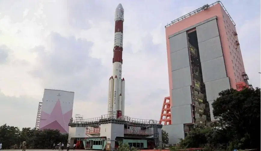
On 27th November 2019, India’s Polar Satellite Launch Vehicle (PSLV), placed 13 Nanosatellites from the United States plus an Indian Earth Observation Satellite – the CARTOSAT-3 – into orbit. While ostensibly for earth observation to assist with infrastructure and coastal development, the image resolution of 25cm lends itself to defence purposes.
India has a long history of deploying dual purpose satellites with civilian and military purposes. India today has some fourteen operational satellites dedicated to remote sensing, making the Indian Remote Sensing (IRS) series the largest civilian remote-sensing constellation in orbit. All of the IRS satellites are placed in polar sun-synchronous orbit, being launched by the Polar Satellite Launch Vehicle (PSLV), making both the satellites and launch vehicle entirely India. The IRS satellites provide data in a variety of spatial, spectral and temporal resolutions, some having a spatial resolution of 1 meter or below which with definite military applications.
An early experiment in this regard was theTechnology Experimental Satellite (TES) which was launched in October 2001. The TES had panchromatic camera capable of producing images of 1 meter resolution and was perhaps India’s first ostensible reconnaissance satellite. This does not mean that earlier IRS satellites did not have military applications but rather reflects the greater military utility of the lower-resolution afforded by the TES.
One of the more recent satellites with clear military applications was the Radar Imaging Satellite 2 (RISAT-2) which has a synthetic aperture radar (SAR) purchased from from Israel Aerospace Industries (IAI). It has a day-night, all-weather monitoring capability and has a resolution of one meter, enabling it to track ships at sea. The RISAT-1, launched later than the RISAT-2, was also fitted with a SAR system and augments the former in surveillance tasks.
The CARTOSAT family of satellites – a subset of the IRS family – are probably the most capable of India’s military satellites. The CARTOSAT-2A is a dedicated military satellite whose capabilities are as yet unclear but it is capable of being steered to enable the imaging of any particular area with greater frequency. It reportedly has a resolution of 2.5 metres.
Its predecessor – the CARTOSAT-2 – carries a state-of-the-art panchromatic (PAN) camera that can take black and white photographs in the visible region of the electromagnetic spectrum. The swath covered by these high-resolution PAN cameras is 9.6 km and their spatial resolution is 80 centimeters. CARTOSAT-2 can be steered up to 45 degrees along as well as across the track and is capable of providing scene-specific spot imagery. Its successor, CARTOSAT-2B offers multiple spot scene imagery.
In 2017, the CARTOSAT-2E was launched. This provided scene-specific images with a spatial resolution of less than 60 centimeters and marked a remarkable improvement in India’s satellite imagery. The latest member of the CARTOSAT family, the CARTOSAT-2F, was launched in January 2018. It has four MX detectors with bandpass filters between 450 and 860 nanometers which can deliver imagery at a two-meter ground resolution along a 10-Kilometer swath. While its principal tasks are for disaster management, cartography, and environmental monitoring, its military applications are evident. One might expect further improvements in follow-on satellites.
Aside from remote sensing satellites, ISRO has fielded a wide variety of communications satellites. The INSAT series of satellites has provided transponders for communications for several decades. Of the twenty-four satellites put into orbit, eleven are currently operational with ISRO making more use of the Indian Geostationary Satellite Launch Vehicle (GSLV), as opposed to the French Ariane rocket, as the reliability of the GSLV improves. INSAT-4F, also known as GSAT-7, is a dedicated military communications satellite with the Indian navy making extensive use of the satellite to facilitate communications between its ships. GSAT-6, launched in 2015, also purportedly provides secure communications to several strategic end-users in India.
More recently, India has completed all the building-blocks for its own satellite navigation system. Six IRNSS satellites are currently in operation, providing the foundation for the development of an Indian navigation satellite system – NAVIC. This will provide both a standard positioning service for civilian users and an encrypted positioning service for military users.
While six satellites are sufficient to start the NAVIC system, an attempt to place a seventh satellite into orbit failed in 2017. This satellite, which was to replace the earliest member of the family – IRNSS-1A – was to provide the necessary redundancy for the NAVIC system. There are plans, however, to increase the number of satellites to eleven, thus increasing the coverage area.
Cover image: PSLV C-47 – Credit: Times of India


